
- Main page
- News
KazNU REMOTE SOUND CENTER
5/17/2021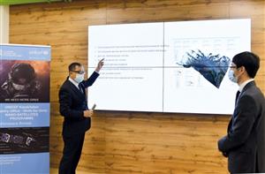
The commandment of our ancestors "Know the seven kinds of teachings" is a professional principle for innovative young scientists of Al-Farabi Kazakh National University. Our specialists, who have mastered the language of space technology, have created new projects that will help increase the potential of the country's economy. For example, since 2018, the University's Center for Remote Sensing (ERS) has been developing geoproducts for various industries based on geographic information systems (GIS) and satellite imagery.
Geoinformation products are the results of expertise obtained on the basis of remote sensing, ie observation data. Cartographic, statistical and meteorological data from other sources are also used. This system is an indispensable approach to significant changes in many sectors of the economy. For example, it is most effective for agriculture, construction, emergencies, ecology, environmental protection and transportation. Such innovative products are a direct way to be competitive in the world market.
According to Omirzhan Taukebayev, Deputy Director General of the Engineering and High Technologies Cluster of the University, the main activity of the center is the acquisition, processing and distribution of space images of different spatial accuracy. Carrying out various analytical works, monitoring using this information. Also to teach students the basics of geoinformation applications.
In 2019, Al-Farabi Kazakh National University signed a partnership agreement with SuperMap. Accordingly, the University has the right to distribute, train and provide technical support for SuperMap GIS software in Central Asia and Russia. SuperMap is the world's largest manufacturer of geographic information platforms and has more than 1,000 partners around the world, including HUAWei, IBM, and Microsoft.
The main features of the Earth Remote Sensing Center of KazNU are:
The center has a virtual station SatSee, which belongs to the Chinese Academy of Sciences.
This allows you to take pictures of the desired area in QuickLook mode from five Chinese satellites, seeing the flying trajectory of the US spacecraft LandSat. In other words, the large number of spacecraft creates a favorable environment for faster and more frequent data acquisition than other Kazakhstani systems.
- Today, the Earth Remote Sensing Center not only monitors the ground, but also conducts internships for students and undergraduates of university departments. This academic year, together with SuperMap, the Department of Geography and Nature Management, Mechanics and Mathematics has installed 30 licenses for the SuperMap iDesktop program. In addition, on the basis of the Department of Cartography and Geoinformatics opened a laboratory "Geoinformation Cartography" on the basis of innovative products of SuperMap. This program meets all the standards of the world and the main difference is that it can work on all platforms, such as Big Data, Artificial Intelligence and 3D GIS, which are modern trends. Another important point is that the program has the ability to perform more than 600 analyzes, - said Omirzhan Taukebayev.
Saves what is saved
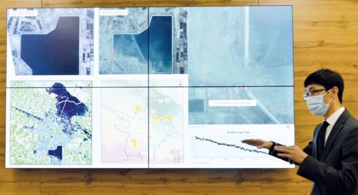
According to Omirzhan Zhalgasbekovich, when the Sardoba reservoir exploded last year, the Earth Remote Sensing Center conducted a joint study with experts from the Institute of Aerospace Research of the Chinese Academy of Sciences. Based on satellite images of the GF-3 satellite, the area of flooded areas was identified and analyzed in a short time.
- At that time, together with specialists from the Institute of Aerospace Research of the Chinese Academy of Sciences, based on satellite imagery, we found that a 234-meter-long dam had burst. When analyzing the numerical model of the terrain, it became clear that the water flowing from the Sardoba reservoir to the territory of Kazakhstan flows only at a distance of 25-30 km. For example, if the reservoir is 287 meters above sea level, the level of the border areas will drop to 210-215 meters, - he said. At the same time, it was possible to monitor the process of flooding in rivers through remote sensing technology. In addition to satellite imagery, meteorological data such as temperature, snow cover, and precipitation are used.
In 2019, representatives of the center analyzed 240 km of the Irtysh River. There are 65 settlements with an average population of about 138 thousand people. As a result, in May, the canal was flooded. This will allow flood prevention and agricultural planning.
Monitoring of moraine lakes
Such lakes are formed in mountainous areas under the influence of glaciers. However, in the spring and summer, a calm lake in the mountains may overflow and cause catastrophic floods. Therefore, these lands are under the control of specialists.
- Currently, the Earth Remote Sensing Center is working to create an automated monitoring system for moraine lakes and mobile hybrid container-type power plants. There are 945 moraine lakes in Kazakhstan, 47 of which are dangerous. 14 of them are located near Almaty. In addition, flood and landslide-prone areas in the country need regular monitoring. The use of space technology will help prevent disasters caused by natural and anthropogenic factors and reduce losses. And an automated intelligent system can measure several indicators at once. For example, it instantly determines water quality, soil temperature and humidity, and precipitation. And experts analyze the situation on the basis of the same data, sitting in the situational centers. In addition, 360-degree cameras will be installed to keep the situation under control, - said Mr. Omirzhan.
The main features of the Earth Remote Sensing Center of KazNU:
- Ability to take high-quality images of the desired area;
- can transmit data faster and more frequently than in Kazakhstan;
- Facilitates the work of relevant structures and regional akimats.
The Earth Remote Sensing Center provides space monitoring services in the following areas:
- in case of forest and steppe fires;
- during mudflows and floods;
- pastures;
- arable lands;
- facilities for burial of household waste;
- identification of new facilities;
- Development and implementation of a geographic information system (geoportal).
The mainstay of tourism
The remote sensing center will also contribute to the development of tourism. For example, last year, in order to develop tourism, the center of our university together with Turanga Group LLP developed a map for tourists. The map shows three trails and tourist facilities in the Ayusai gorge, located in the Ile-Alatau National Park. At the same time, information about the length and complexity of the road became available to tourists. In the future, it is planned to develop an application for smartphones and create a geoportal. Because all of this information is in digital format, it is very easy to edit it. Therefore, the map can be updated at any time as the infrastructure improves. Specialists of the center, along with representatives of the travel company, walked all three trails. This is necessary "to make sure that the data is correct and to avoid mistakes," said Omirzhan Zhalgasbekovich.
Control and planning
- We have another point that will be useful for local executive bodies, - says Mr. Omirzhan. - For example, monitoring of landfills with satellite imagery has become available. The landfill near Almaty is located near the village of Aitei. The amount of waste has increased 2.5 times over the past decade. This method helps to identify illegal landfills and unburied solid waste. This would also be a project aimed at preventing environmental problems.
One of the areas in need of new technologies today is agriculture. The state invests a lot in the development of this industry. Remote sensing of land will allow in the future to plan arable land on those lands, to predict their productivity.
In short, the use of geographic information systems and Earth remote sensing data has led to significant changes in the era of globalization. The countries of the world have used it effectively and achieved great results. For example, Malaysia is using this technology to create a smart city, while Thailand is using Smart-Agriculture, ie China, and China is using a geoportal to prevent emergencies. Some countries even control the movement of goods through the use of geographic information systems in the field of logistics. If such projects are ordered by the state or local executive authorities, our specialists will create a new competitive project.
Camilla Duisen