
- Main page
- News
SUPERMAP PROVIDED BY SMART-SOLUTIONS
6/8/2021
In the last century, we have experienced an industrial and technological revolution. The next stage is called the "information revolution". Because the XXI century is a time of striving for heights through BIG Data. Collecting, processing and analyzing data is today's demand. In short, they are called geographic information systems (GIS). Today we are talking about a program that will help you create a project that meets such demand.
In general, what are geographic information systems? It is a structure for data collection, management and analysis. It has four columns: maps, data, analysis and programs. Based on geography, this system combines many types of data. It analyzes spatial layout using maps and 3D views and organizes layers of information in visuals. Thanks to this unique feature, GIS allows users to analyze data in depth, which helps them make smart decisions. Thousands of organizations in all industries use this technology to create maps that analyze data, exchange information and solve complex problems. In this way, the way the world works has changed radically.
Earlier it was reported that KazNU scientists have developed several projects that will serve society with the help of space technology. Gaukhar Batay, a specialist at the Center for Remote Sensing of the Al-Farabi Kazakh National University, said that one of the main tools in the work is the SuperMap program. SuperMap develops and offers the latest innovative platforms and solutions for geographic information systems for global customers. The company's product line includes a full range of desktop, service, component and mobile GIS software. Therefore, it is one of the most advanced software platforms for geographic information systems. The SuperMap technology system is called BitDC. That is, B-BigData, I - artificial intelligence, T - 3D measurement, D - distributed technology and C - cross-platform. These five are the main directions of the company's development of GIS technologies.
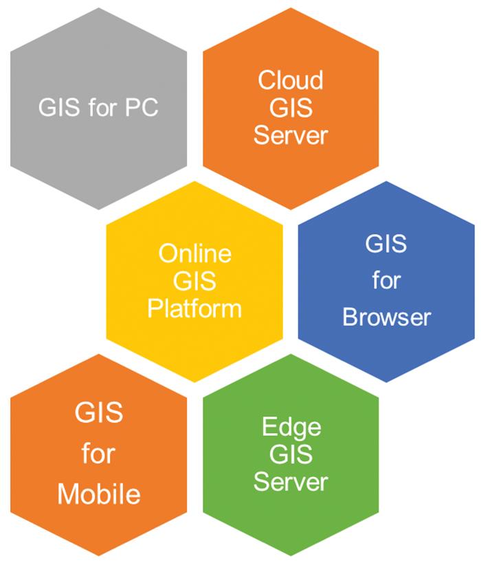
SuperMap is a complete GIS platform software package that includes desktop, service, component and mobile geographic information system platforms, as well as spatial data generation, processing and management tools.
The main products of SuperMap
SuperMap iDesktop is a simple, stable and efficient GIS software. It is available in three basic, standard, professional and advanced versions. It includes data processing, mapping, 2D and 3D integration analysis, graphics, drawing, and more. has a complete set of geographic information system functions. SuperMap iDesktop simplifies a lot of work for professionals who process and analyze spatial data in various fields and require individual GIS applications at work.
According to the center's expert, one of the features of the SuperMap desktop geographic information system is that it can be updated online. The user can easily study the dynamic segmentation and hydrological analysis, taking into account the mechanism of the work process. In addition, due to the different formats and mechanisms of data, it fully meets the requirements of the user.
(The main products of SuperMap)
Why choose SuperMap iDesktop?
In SuperMap iDesktop software, data can be displayed, processed, and analyzed in 2D or 3D format, and this does not require running 2D and 3D GIS in separate software. Such features significantly improve work efficiency. It also uses a multi-document interface (MDI) to display, process, and use data by opening it in multiple map windows at once. The latest tape interface is used to increase work efficiency and reduce visual fatigue.
SuperMap iServer
SuperMap iServer is a cloud GIS server based on a high-performance cross-platform GIS core. It has 2D, 3D integrated services publishing and management functions. It also provides multi-level expansion and development. You can quickly publish local and remote data as a SuperMap iServer service.
SuperMap iServer offers many GIS features such as maps, data analysis, 3D, Big Data and artificial intelligence, and a full range of interfaces, including interfaces, security and clustering.
SuperMap iPortal
It is a GIS portal platform for integrating, searching, allocating and managing GIS resources. SuperMap iPortal has advanced technologies and features such as zero code display control, registration of heterogeneous services from multiple sources and system control panels. SuperMap offers many web applications with an iPortal thematic display, three-dimensional visualization, distributed spatial analysis, a large screen display, and template applications.
AI GAZ
AI (Artificial Intelligence) geoinformation system is an integration of artificial intelligence and GIS. It specializes in managing, visualizing and analyzing GeoAI results. Optimizes user interface experience, operation and maintenance.
The AI GIS workflow tool supports the basics of model creation, model learning and application, image data classification, video data purpose definition and control, binary classification, landscape classification, relief classification, and more. analyzes image data, including functions.
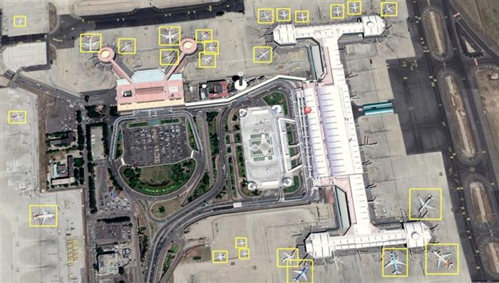
(Recognition of objects on the basis of artificial intelligence)
Large GIS data
Gold Mine, which includes large-scale data storage and management, spatial analysis, streamlined data processing technology and visualization. Large GIS data - Spark offers flexible processing capabilities for distributed media. Provides abundant and stunning spatial visualization of big data.
SuperMap solutions
SuperMap offers smart solutions to the following issues: smart city, facility management, transportation, land management, natural resources, public safety, natural disasters and water conservation.
At present, the construction of smart cities has entered a new stage of pragmatic development with innovative technologies. With the help of the platform can exchange, share and coordinate city information resources. Provides comprehensive support for urban management and services. The most basic solution of a smart city is an effective combination of various basic, thematic and dynamic information of the city.
In terms of facility management, SuperMap is used to develop specific applications such as rail, road and transport facilities, electricity, communications, water supply and sewerage, heat and gas supply. It also manages production equipment, buildings and other data, facilities and property and works in conjunction with the ERP (automation of business processes of the company) system.
GIS has powerful information services and traffic management functions that can be applied to all aspects of traffic management. Compared to traditional methods, the use of GIS technology has unprecedented advantages in transportation planning, traffic management, traffic management and related issues.
SuperMap on land management is aimed at the application of innovations and new technologies in the land industry with more than 20 years of design experience. SuperMap provides land management, information management and use, land monitoring. For example, in Turkey, SuperMap helps to create a digital 3D cadastre to update the cadastral data size.
SuperMap explores the structural theory of natural resource informatization, integrates key issues of natural resources and offers new methods and ideas for natural resource informatization with advanced technologies such as spatial data, 3D-GIS and artificial intelligence.
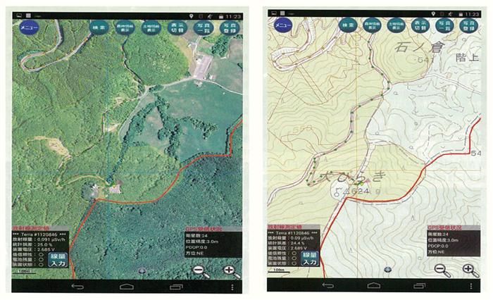
("High-precision portable deployment device for GIS forestry" SuperMap iMobile for Android devices ")
For example, in forestry management, the GIS Forestry High-Accuracy Portable Deployment Device is based on the SuperMap iMobile for Android devices with GPS functions. In addition, SuperMap manages disaster recovery data collection, local data collection and reporting, coordination of tasks with multiple terminals locally, mapping and inspection of the accident site, natural disaster assessment, comprehensive post-disaster information disclosure services, and disaster information. supports sharing.
Camilla Duisen